Guide to Cedar Creek
Cedar Creek Water Quality
Matt Jones
Natural riffle, run, glide features in Cedar Creek (Heather Baker)
Cedar Creek originates in the Eel River outwash plain and crosses the Wabash moraine to the St. Joseph River outwash plain. Cedar Canyon is an example of “river piracy,” a classic tunnel valley created between two separate lobes of ice during the last glacial age.
Chief Metea’s Potawatomi village, “Muskwawasiipiotan,” was located close to the mouth of Cedar Creek.
Recognized by the state as an “Outstanding State Resource Water,” Cedar Creek is designated by the state of Indiana as a recreational river, one of only three “Natural, Scenic and Recreational River Systems” in the state.
Cedar Creek’s waters are a subwatershed of the St Joseph River, which feeds into the Maumee River, which eventually empties into Lake Erie. Together with the larger St Joseph River, Cedar Creek is the source of drinking water for Fort Wayne and surrounding communities.
The topography, structure, and land uses along these rivers create the highest water quality of any surface water available to the Fort Wayne City Utilities Water Treatment plant. This high water quality is due in part to the natural riffle, run, glide and pool features evident along most of the Cedar Creek and the St. Joe River. These natural features make for better oxygenation and less stagnation.
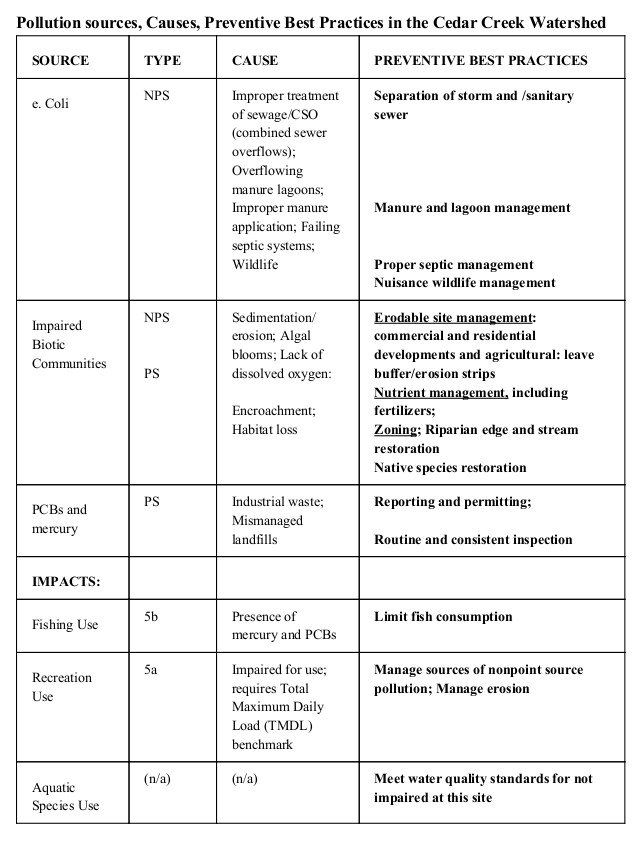
However, Cedar Creek canyon waters are classified as “impaired.” Cedar Creek impairments are E Coli, Impaired Biotic Communities, and PCBs (see chart).
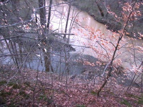
What is contaminating the natural water quality along both Cedar Creek and the St. Joseph river? The answer is both PS - point-source pollution, such as from a pipe, vent, or culvert, and NPS--nonpoint-sources of pollution such as that caused by runoff from paved surfaces and agricultural land. (This article’s photo shows the difference in the color and clarity of water at the confluence of Cedar Creek and its tributary, Willow Creek, spring 2017. You are seeing severe sedimentation in Cedar Creek from agricultural runoff.) Nonpoint-source pollution is related to human behaviors that make pollution abatement difficult. These behaviors--and the resulting pollution--continue to multiply under the stresses of increasing industry and population booms that lead to increasing development.
As these stressors have increased, so have the different types of contamination that harm our drinking water. The contamination also harms fishing, hunting, and recreation --all renewable and mostly sustainable attractions and resources that depend upon the natural habitat. All will improve as water quality improves.
You can take an active part in helping improve Cedar Creek water quality by following, and sharing with others, the suggestions in related linked articles. Friends of Cedar Creek strongly support the “Preventive Best Practices” and “What You Can Do to Help Keep Cedar Creek Unpolluted” below.
What Can I Do to Help Keep Cedar Creek Clean and Unpolluted?
Make these improvements at home and around your property and share this list with others:
- Inspect and maintain septic systems.
- Disconnect downspouts to spread out impact of water coming off roofs.
- Divert stormwater into rain barrels and rain gardens.
- Reduce impervious surfaces such as concrete and asphalt
- Use native species whenever and wherever possible (see "Native Plants" in this Guide.)
- Do not remove native plants, including trees and other vegetation, from or near stream banks because their roots hold the earth and keep sediment from washing into Cedar Creek!
- Properly dispose of noxious chemicals; never discard them around your property or near storm drains.
- Always read directions for chemicals before applying them.
- Remember the 4 “R’s” to apply fertilizer: Right Reason at the Right Rate in the Right Place at the Right Time.
More to Explore . . .
- Allen County Partnership for Water Quality (ACPWQ) -Site for publications for information, streaming, or download. www.acwater.org.
- Allen County Soil and Water Conservation District (AC SWCD) -Site for agricultural and other land and water conservation initiatives. www.allenswcd.org.
- Environmental Protection Agency (EPA). Clean Water Rule Protects Streams and Wetlands Critical to Public Health, Communities, and Economy. News Release. May 27, 2015.
- "Native Plants." Carol Roberts. Guide to Cedar Creek. 2017.
- St. Joseph River Watershed Initiative (SJRWI) -Site for information and management plans concerning the St. Joseph River watershed. www.sjrwi.org.


